IUCN Pakistan launches Mangroves Assessment Report at COP29
IUCN Pakistan launched the Mangroves Assessment Report on Pakistan in a ceremony presided by the Chief Minister of Sindh province, and other Ministerial and foreign delegates at the 29th Conference of the Parties to the United Nations Framework Convention on Climate Change (COP 29) held in Baku, Azerbaijan.
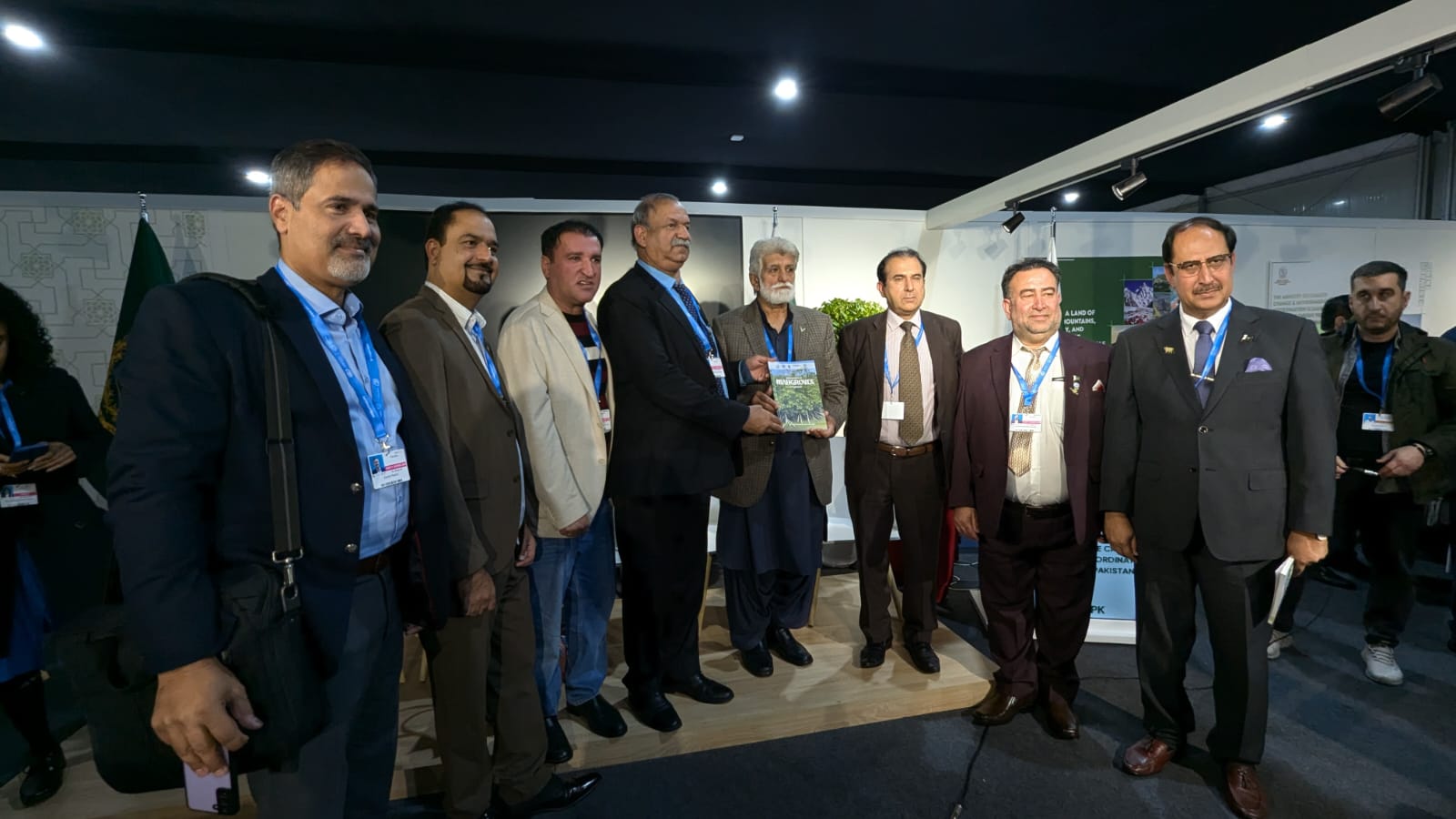
The launch was held at the Pakistan Pavilion, co-organised by the Ministry of Climate Change and Environmental Coordination and IUCN Pakistan. Delegates at the launch included representatives of the Pakistan government, federal and provincial line departments, international delegates as well as environmental and climate change experts from different parts of the world.
The IUCN delegation from Pakistan was led by Mr Mahmood Akhtar Cheema, Country Representative of IUCN Pakistan, who presented the report to the Chief Minister of Sindh Syed Murad Ali Shah.
Covering the entire coast of Pakistan, the report outlines the overall status of mangroves growth in Pakistan, the threats it faces and the role of institutions in protecting and restoring degraded areas with mangroves.
The report further highlights the recent causes of mangrove degradation and loss, noting that these issues are similar across the four South Asian countries of Pakistan, India, Bangladesh and Sri Lanka. The identified threats include overharvesting of wood, animal fodder and fishery resources; reduction in the supply of freshwater and silt ; coastal erosion; pollution; the impacts of storms and tsunamis; and conversion of mangroves to other land uses. The report also recognises the significant efforts of the Sindh Forest and Wildlife Department in expanding mangroves cover and protecting natural forests.
Speaking on the occasion, Mr Cheema highlighted the significance of the mangroves assessment and termed it very timely, given the current challenges being faced due to exacerbating climate change impacts on the Pakistan coast. He added that mangroves serve as highly efficient carbon sinks—up to four times more carbon-rich than terrestrial forests. They also contribute significantly to improving community livelihoods through improved fish catch.
The Chief Minister of Sindh province, Syed Murad Ali Shah, commended the efforts of the Sindh Forest and Wildlife Department and IUCN Pakistan for their collaboration in enhancing the mangrove cover in the country, which has significantly contributed to increasing Pakistan's overall forest cover.
The Chief Minister also spoke about the collaboration between IUCN and Indus Delta Capital Ltd in the Delta Blue Carbon project and he assured that such initiatives have not only helped reduce emissions but would also support community livelihoods.
The mangroves assessment report can be accessed
here.
Additional Section: Climate Change Trends in Pakistan
Introduction
Pakistan’s vulnerability to climate change impacts is well documented and acknowledged. In the past decade, recurrent spells of extreme weather events such as floods, droughts, glacial lake outbursts, cyclones, and heat waves have taken a heavy toll on both life and property and adversely affected the country’s economic growth. The super flood of 2010 alone, for instance, killed 1,600 people, inundated an area of 38,600 square kilometers (km²), and caused damage worth around $10 billion. Similarly, the Karachi heat wave in June 2015 led to the death of more than 1,200 people.
A. Country Overview
Geography and Climate
Pakistan extends over an area of 796,000 km² with a great diversity in temperature and precipitation. The eastern areas of the southern half mainly receive precipitation through the southwest summer monsoon (from June to September), while the northern and western areas of the southern half of the country get rains mainly through western weather disturbances in winter (from December to March). The summer monsoon accounts for around 60% of the total annual precipitation. The climate varies from arid to semi-arid, where three-fourths of the country receive rainfall of less than 250 millimeters (mm) annually, except in the southern slopes of the Himalayas and the sub-mountain region in the northern segment of the country, where annual rainfall ranges from 760 mm to 2,000 mm. The northern region includes some of the world’s highest mountain peaks, such as K-2 (8,611 meters [m] high), and the largest glaciers including Siachen (70 kilometers [km] long) and Biafo (63 km) that feed the Indus River and some of its tributaries. During winter, the temperatures in this region drop to as low as –50°C and stay around 15°C in the warmest months of May to September.
The western and southern segments of the country represent the Indus River basin plain and Balochistan Plateau. The transboundary Indus basin covers 520,000 km² or 65% of the country’s total area, including the whole provinces of Punjab, Khyber Pakhtunkhwa, most of the Sindh territory, and the eastern part of Balochistan. The Indus Basin Irrigation System is the world’s largest contiguous irrigation system, accounting for 95% of the country’s total irrigation system. The average annual rainfall in the Indus plain is around 230 mm. The temperature differences between the upper and lower basin plains are quite noticeable: the mean winter temperature (December–February) in the lower plain is 14°C–20°C, and 20°C–23°C in the upper plain areas, while during summer (March–June), the mean monthly temperature varies from 42°C–44°C in the lower plain , and 23°C–49°C in the upper plain.
The Balochistan Plateau is a vast wilderness of mountain ranges in the southwest of the country with an average altitude of about 600 m. Some seasonal rivers cross this region, but most of its northwestern part is a wide expanse of desert similar to the deserts found in the central part of the country, such as Thar and Cholistan. The rainfall in this region is less than 210 mm annually or 20–30 mm per month.
Demography
Pakistan is the sixth most populous country in the world with a population size of 184.5 million. With the current average annual population growth rate of 2%, it is projected to be the fifth most populous country in the world by 2050. The density of the population is 231 persons per km², with almost 37% of the population residing in urban areas, of which around 47% are slum dwellers. The current total fertility rate of 3.8 is one of the highest in the Asia Pacific region, and the country holds the second highest out-of-school population in the world, of which two-thirds are girls.
Climate Threats
The Intergovernmental Panel on Climate Change (IPCC) Fifth Assessment Report (AR5) for the Asia region notes that sensitivity to climate change threats in agriculture-dependent economies (such as Pakistan) arises from their distinct geography, demographic trends, socioeconomic factors, and lack of adaptive capacity that, when taken together, determine the vulnerability profile by perpetuating a vicious cycle of poverty. The climate change projections of the AR5 for South Asia as a whole show that warming is likely to be above the global mean, and climate change will impact the glaciers’ melting rate and precipitation patterns, particularly affecting the timing and strength of monsoon rainfall. Consequently, this will significantly impact the productivity and efficiency of water-dependent sectors such as agriculture and energy.
Climate Change Trends in Pakistan
1. Observed Past Climate Trends
a. Past Changes in Temperature over Pakistan
A significant warming trend of about 0.57°C in the annual mean temperature was observed in the past century from 1901 to 2000 in Pakistan. This increase is less than the mean annual temperature increase of 0.75°C in the past century in the South Asia region. A more accelerated trend of warming, with the rise of 0.47°C, was observed from 1961 to 2007 in the country. The warmest year recorded until 2007 was 2004, and the highest increase is observed during winter when the temperature ranges from 0.52°C to 1.12°C. This is in agreement with the pronounced rate of warming observed over the South Asia region in the decade 1998–2007, which was attributed to an increase in winter temperature and post-monsoon changes. On a regional basis, the highest increase in winter temperature was observed for Balochistan province, while the northwestern parts of the country showed negative temperature trends in the summer. The annual temperatures in Pakistan increased by 0.87°C (maximum) and 0.48°C (minimum) from 1960 to 2007.
Based on the Pakistan Meteorological Department (PMD) station data from 1951 to 2000, a rising tendency in the annual mean surface temperature was observed throughout the country. In the hyper-arid plains, arid coastal areas, and mountain regions of Pakistan, an increase of 0.6°C–1.0°C in the mean temperature was observed, whereas an increase of 0.5%–0.7% in solar radiation was noted over the southern half of the country. In central Pakistan, the cloud cover decreased by 3%–5% with a consequent increase of 0.9°C in temperature. The northern parts of the country outside the monsoon region suffered from expanding aridity during the study period.
Future Projections
- Pakistan’s projected temperature increase is expected to be higher than the global average.
- Projected temperature increase in northern parts is expected to be higher than the southern parts of the country.
- The frequency of hot days and hot nights is expected to increase significantly.
- Pakistan’s rainfall projections do not indicate any systematic changing trends.
- Major crop yields such as wheat and rice are expected to decrease significantly.
- Water availability per capita is projected to decrease to an alarming level.
- An increasing trend in rainfall over the Upper Indus Basin and a decreasing trend in the Lower Indus Basin.
b. Past Changes in the Mean Precipitation Over Pakistan
During 1951–2000, a decrease of 10%–15% in winter and summer rainfall in arid plains and coastal areas was observed while a rise of 18%–32% in the summer rainfall was observed in the core monsoon region of Pakistan. A decrease of 5% in relative humidity was observed in Balochistan province. Similarly, a decrease of 17%–64% in rainfall was observed during the seven strong El Niño events in the last 100 years. Depressions, storms, and cyclones forming in the Bay of Bengal and Arabian Sea increased in frequency during the last decade of the 20th century and have been affecting Pakistan as well as other countries in the region.
For a long-term precipitation time series, 18 stations with available data from 1901 to 2007, and five stations with available data from 1914 to 2007 were used. A 10-year moving average showed that rainfall gradually decreased from 600 millimeters (mm) to 400 mm a year from the early 1900s to 1940. After 1940, an increase of 133 mm was observed. Annual precipitation increased by 61 mm in Pakistan from 1901 to 2007. Monsoon rains increased by 22.6 mm, and winter precipitation increased by 20.8 mm.
c. Past Changes in the Climate Extremes of Pakistan
A significant increase in the number of heat wave days per year with a rate of 11 days per decade was observed in Pakistan. The trends for 5, 7, and 10 consecutive days rose very sharply, indicating the increased frequency of heat waves in Sindh from 1961–2011. The study for Sindh shows a sharp increase in the intense heat wave events, calculated for temperatures ≥45°C for 5, 7, and 10 consecutive days. During the period 1961–1990, the heat wave events were less frequent. However, from 1990 to 2011, an increase in the frequency of these events is noticed. It is expected that with high temperatures in the long run, heat waves will become more frequent and intense all over the world, including Pakistan.
A rise of 30–60 days in cold wave is observed in the northwestern parts of the country, and the number of cold wave days in Punjab and the southern areas of Sindh province decreased. However, no significant trend is observed in the average number of cold wave days across the country. No significant trends are noted in the frequency of consecutive wet and dry days.
Sea Level Rise
Sea level rise for Pakistan is estimated at 1.1 mm per year (mm/year) from 1856–2000 along the Karachi coast. According to the IPCC AR5 Working Group I report, global mean sea level rose 0.19 meter (m) over the period 1901–2010. The rate of change was markedly higher during the later period: the mean rate of the global average sea level rise was 1.7 mm/year between 1901 and 2010, and 3.2 mm/year between 1993 and 2010. The change in sea level was due to two major processes: thermal expansion of the ocean from global warming and glacier mass loss.
2. Projections of Future Climate Trends in Pakistan
a. Future Trends of Temperature and Precipitation
Using the General Circulation Model for future climate change projection, the Global Change Impact Study Centre (2007) modeled annual temperature and precipitation change for future years 2020, 2050, and 2080 under two emissions scenarios of A2 and A1B. According to the model, by 2080, the temperature increase in Pakistan will be as high as 4.38°C. Regarding regional change in annual temperature, the study further noted that (i) the temperature increase in both summer and winter are higher in northern than southern Pakistan, and (ii) the temperature increases in both regions are higher in winter than summer. For the percentage of precipitation change, no significant change is observed. However, there is some precipitation increase in summer and a decrease in winter in southern Pakistan.
In the Indus Basin area, one important study projects an almost uniform variation in the rainfall distribution over the entire basin region. At subregion levels of the Upper Indus Basin (UIB) and Lower Indus Basin (LIB), the models show an increasing trend in the rainfall over the UIB, decreasing in the LIB with a small change in the border zone between the two basin subregions. Winter precipitation is projected to decrease, particularly in the southern part of the basin with greater warming in the winter than in other seasons of the year. Similarly, UIB will become warmer than LIB. The model simulations also suggest a rise in the total number of rainy days over the basin, but a decrease in the number of rainy days, and an increase in rainfall intensity is projected in the border zone between the upper and lower basins, where the volume of rainfall is highest.
b. Projected Sea Level Rise
In the past century, the average mean sea level rose to 1.1 mm/year for Pakistan. It is difficult to project sea level rise (SLR) by the end of 2100 for Pakistan, since data is limited at the country level. However, the sea level rise projections at the global and regional levels can be helpful in capturing the extent of the risk Pakistan will be exposed to in the future. IPCC AR5 notes a global mean SLR of 0.2–0.6 m by the end of this century, whereas for South Asia, of which Pakistan’s coast is a part due to the shared Arabian Sea border, 0.7 m (with a range between 0.42 and 1.12 m and a 90% level of confidence) SLR is projected by 2100 on average, relative to the pre-industrial level. Future sea level rise will most likely affect the low-lying coastal areas south of Karachi toward Keti Bander and the Indus River delta.


Restoring Our Landscapes: A Global Effort under The Restoration Initiative Land degradation is a…
The Ministry of Climate Change and Environmental Coordination (MoCC&EC), Government of Pakistan…
IUCN Pakistan awarded four small grants worth six million Pakistani rupees each to local NGOs in…